
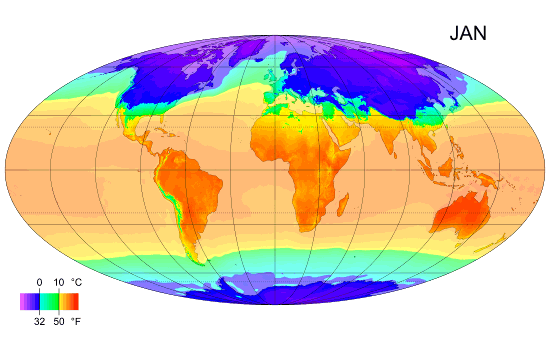
Check out the key below for deeper understanding of what you are looking at.
Source: http://www.ncdc.noaa.gov/data-access/model-data/model-datasets/reanalysis

A 3-D animated image of Reanalysis-2 data for the first ten days of July 1979, in six-hourly intervals. This animation shows a constant 100mph wind speed surface in red. (Note the stronger, more widespread, polar jet stream in the southern hemisphere--this is July, during the southern winter.) A cyan-colored, constant temperature sheet of zero degrees Celsius ripples across the globe, showing the freezing level. Near-surface wind flow is denoted by white flowlines. This image was generated with plots from Unidata's Integrated Data Viewer (IDV) combined with ImageMagick.
Mean Sea Surface Temperatures

A plot of global, monthly mean wind speeds and directions
for September 1990. These data are from the Blended Sea Winds dataset,
available through NOMADS. This image was produced with NASA’s Panoply
visualization tool.
Here is a cool gif relating to what we are investigating in science and mathematics in MYP2
source: http://en.wikibooks.org/wiki/High_School_Earth_Science/Climate_and_Its_Causes
source: http://en.wikibooks.org/wiki/High_School_Earth_Science/Climate_and_Its_Causes
No comments:
Post a Comment